Trigonometry and angles in flight
DRT 111 Applied Mathematics for Technology
Lesson
By the end of this module you will be able to
- Convert angles between degrees and radians
- Use Pythagoras' theorem and the sine, cosine and tangent ratios to solve right triangles
- Find a bearing from coordinate differences with atan2, in the correct quadrant
- Calculate the ground footprint and ground sampling distance (GSD) of a drone camera
- Resolve wind into headwind and crosswind components
Angles are part of every flight
A drone climbs at an angle. A camera looks down with a certain field of view. Wind blows across the flight path at an angle, and pilots give directions as an angle from north. All of these use the same tool: trigonometry, the study of how the angles and side lengths of triangles relate.
By the end of this module you will be able to work out how wide an area a camera at 100 m covers, which is the basis of survey flight planning in DRT 451 and DRT 452.
Degrees and radians
Angles can be measured in two units. Degrees divide a circle into 360 parts. Radians are defined by arc length: one radian is the angle whose arc is exactly as long as the radius. A full circle is therefore radians. The relationship to remember is
For example, rad.
Why do radians matter? Almost all software, including Python and the PX4 and ArduPilot autopilots, works in radians internally. If you pass in degrees without converting, every result will be wrong.
Watch out
Calculators have DEG and RAD modes. Check the mode before pressing sin, cos or tan. is 0.5 in DEG mode but −0.988 in RAD mode.
The right triangle
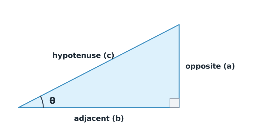
A right triangle has one angle. The longest side, opposite the right angle, is the hypotenuse (). Once you choose an angle to work with, the other sides are the opposite () and the adjacent ().
Pythagoras’ theorem
Trigonometric ratios
A popular memory aid is “SOH-CAH-TOA”: Sine = Opposite/Hypotenuse, Cosine = Adjacent/Hypotenuse, Tangent = Opposite/Adjacent.
If you know a ratio and want the angle, use the inverse function. For example, if , then .
Example 1. Climb angle
A fixed-wing drone travels 300 m horizontally while climbing 100 m. What are the climb angle and the actual distance flown?
- Climb angle:
- Distance flown: m
Bearings and the atan2 function
In navigation, direction is given as a bearing (or heading), measured clockwise from north. North is , east , south and west .
If a target lies metres north and metres east of you, the bearing to it is
Why not simply use ? Because dividing the two values loses their signs, so you cannot tell north-east from south-west. atan2 takes the two values separately and always returns the angle in the correct quadrant.
Example 2. Bearing to a waypoint
A waypoint is 100 m south () and 100 m east ().
- , which points north-west: wrong
- , south-east: correct
In Python: math.degrees(math.atan2(dE, dN)) % 360
Ground footprint and GSD
When a camera looks straight down from height with a given field of view (FOV), the area it captures forms an isosceles triangle, which splits into two right triangles.
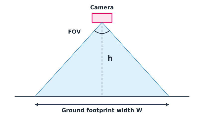
In one half, the adjacent side is and the opposite side is , so . Rearranging:
The ground sampling distance (GSD) is the real ground size covered by one pixel. It equals the footprint width divided by the number of pixels across the same direction:
Example 3. Planning a survey flight
A camera has a horizontal FOV of and images 5472 pixels wide. It flies at 100 m.
- m
- m, about 3.3 cm per pixel
At 50 m both and GSD halve. Images become sharper but you need more flight lines. This is the basic trade-off of mapping.
Resolving wind into components
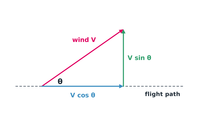
Wind blowing across the flight path has two effects. The part parallel to the path, the headwind, reduces ground speed. The part perpendicular to it, the crosswind, pushes the drone sideways.
Example 4. Wind at 30 degrees
An 8 m/s wind blows towards the drone’s nose at to the flight path.
- Headwind m/s
- Crosswind m/s
If the drone flies at an airspeed of 15 m/s, its ground speed drops to about m/s, so the outbound leg takes almost twice as long. In the next module we will calculate this more precisely with vectors.
Common mistakes
Watch out
- Not checking calculator mode, DEG versus RAD.
- Using the full FOV instead of half. The footprint formula needs .
- Using for bearings. Always use atan2 to get the right quadrant.
- Swapping sin and cos. Name the sides relative to your chosen angle first.
Summary
- rad, and software computes angles in radians.
- Right triangles use Pythagoras and the sin, cos and tan ratios.
- Bearings are measured clockwise from north and found with atan2(ΔE, ΔN).
- Footprint width is , and GSD is divided by the pixel count.
- Crossing wind splits into headwind and crosswind .
Check your understanding
- Convert and to radians.
- A drone is 400 m away horizontally and 120 m up. What is the straight-line distance to it?
- A target is 50 m south and 50 m west. What is its bearing?
- A camera with a FOV flies at 60 m. What is its footprint width?
- A 10 m/s wind is at to the flight path. What is the crosswind?
Answers
- rad and rad
- m
- ; adding gives (south-west)
- m
- m/s
Key formulas
| Degrees to radians | |
| Pythagoras | |
| Trigonometric ratios | |
| Bearing from coordinates | |
| Ground footprint | |
| GSD | |
| Wind components |
Key references
- Abramson, J. (2021). Algebra and trigonometry (2nd ed.). OpenStax. link
- Stroud, K. A., & Booth, D. J. (2020). Engineering mathematics (8th ed.). Bloomsbury.
- Wolf, P. R., Dewitt, B. A., & Wilkinson, B. E. (2014). Elements of photogrammetry with applications in GIS (4th ed.). McGraw-Hill.
Further reading
Study the assigned knowledge units in advance, review media and take the module quiz
Trigonometry, Euler angles and reference frames
Coordinates, direction, time and height
In class / field
Lecture, case discussion and in-class problem solving
Learning evidence: Quiz results and submitted exercises