BVLOS
DRT 342 Mission Planning, Autonomous Operations and Beyond Visual Line of Sight
Lesson
By the end of this module you will be able to
- Define VLOS, EVLOS and BVLOS and identify where each definition comes from
- Explain the air-risk, ground-risk and communication challenges of BVLOS
- Identify the technologies and procedures a BVLOS operation needs
- Summarise the 2026 status of BVLOS regulation in Thailand, the United States and the European Union from primary sources
- Calculate the radio horizon and the flight time of a linear mission
Why this matters
Many of the most valuable drone jobs lie further away than the eye can see: inspecting tens of kilometres of gas pipeline, delivering medical supplies between districts, or searching a forest for survivors. If the pilot must still see the aircraft at all times, these jobs need many people or cannot be done at all.
Flying beyond visual line of sight is therefore an industry goal, but it is a major change for safety, because the pilot’s eyes are an important safety layer: they avoid other aircraft, notice people entering the area and spot abnormal behaviour immediately. Beyond visual range, something else has to do the job of those eyes.
Definitions
| Term | Meaning | Source |
|---|---|---|
| VLOS | An operation in which the remote pilot or observer keeps direct, unaided visual contact with the aircraft | Defined in ICAO Doc 10019 |
| EVLOS (extended VLOS) | The aircraft is out of the pilot’s sight, but observers who can see it stay in constant contact with the pilot | Used in some national rules; not defined in ICAO Doc 10019 |
| BVLOS | An operation in which nobody in the crew sees the aircraft with the unaided eye | ICAO Doc 10019 uses it as an abbreviation without a separate definition |
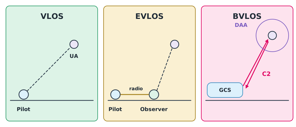
“Seeing” means seeing with the unaided eye well enough to know the aircraft’s position, attitude and surrounding traffic. Watching a first-person-view (FPV) camera feed or a dot on a map is not VLOS.
Why BVLOS is hard
- Air risk: the pilot cannot see an aeroplane or helicopter approaching. A detect and avoid (DAA) system or procedure is needed, or the airspace must be restricted until the risk is low enough.
- Ground risk: a long route crosses many kinds of land with varying population density, and nobody can see people walking under the flight path.
- Communication: all awareness and all commands travel over the C2 link, so link reliability is directly a safety matter (module 4).
- Situational awareness and response: if the aircraft goes down 20 km away, who gets there first, and how is its position known?
Building blocks of a BVLOS operation
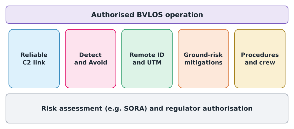
No single technology makes BVLOS possible. All the blocks must work together, on a foundation of a risk assessment the regulator accepts. Examples of mitigations in each area:
- Air: fly low near structures that crewed aircraft avoid, coordinate with air traffic services, and use ground-based or airborne detection
- Ground: route over sparsely populated land, use a parachute, set up controlled areas
- Communication: use two dissimilar links and define a lost-link procedure
- People and procedures: train the crew, write procedures into the OM and rehearse emergencies
Regulatory status (checked 26 September 2026)
BVLOS regulation changes quickly. This table covers only what could be checked against primary sources. Always check the latest version before use.
| Country/region | Status | Primary source |
|---|---|---|
| Thailand | The CAAT notification (in force 17 May 2026) classifies flights that depart from the conditions of the 2015 Ministry of Transport notification as “medium-risk operations (Specific Category)”, requiring a risk assessment and authorisation before flight. The notification does not mention BVLOS explicitly. Details are covered in DRT 343 | Royal Gazette vol. 143, special part 141 Ng |
| United States | The BVLOS ARC submitted its report on 10 March 2022. The FAA published the Part 108 proposed rule on 7 August 2025. No final rule had been published on the date checked | Federal Register; ARC report |
| European Union | Regulation (EU) 2019/947 divides operations into open, specific and certified categories. Operations above open-category risk need authorisation in the specific category based on a risk assessment | EUR-Lex |
The common trend is risk-based regulation. Authorisation depends on where you fly, how high, how large the aircraft is and which mitigations are in place, not simply on the word BVLOS. The SORA method in module 5 is the main tool used by many countries.
Physical limits
Radio horizon
High-frequency radio links travel in almost straight lines, so the curvature of the earth eventually blocks them. The atmosphere bends the waves slightly downward, so an earth radius of 4/3 of the real value is commonly used (ITU-R P.530 gives a median k-factor of about 4/3). The approximate radio horizon is:
where and are the antenna heights at the two ends in metres. The formula comes from with and km.
Example 1 Radio horizon
The ground station antenna is 10 m high.
- Drone at 90 m: km
- Drone at 30 m: km
The radio horizon is a theoretical upper bound. In practice hills, buildings and trees block the signal long before this distance, and transmit power and receiver sensitivity also limit range (DRT 341 module 3). Long-range BVLOS missions therefore often use relay stations, cellular networks or satellites.
Flight time and choice of aircraft
Example 2 Inspecting a 30 km pipeline
A 30 km pipeline must be flown out and back at 20 m/s airspeed, with a 5 m/s tailwind on the way out.
- Outbound s minutes
- Return s minutes
- Total about 53 minutes, excluding take-off, landing and reserve
This exceeds a typical battery multirotor. Missions like this suit fixed-wing or VTOL aircraft, or must be split into sections with battery changes along the route.
Example 3 Why EVLOS cannot be stretched forever
Assume each observer can reliably watch the drone within a 500 m radius (an exercise assumption; the real distance depends on drone size, background and weather). A 6 km route then needs observers in a line. Each needs a radio and must hand over the watch without gaps. The longer the route, the higher the cost and the chance of a handover error. This is why the industry is moving towards technology-based BVLOS.
Concept of operations (ConOps)
Every BVLOS authorisation starts with a concept of operations document that explains what will be flown, where, when, how, who is responsible and what happens when things go wrong. It matches the first step of SORA. The clearer it is, the easier it is for the assessor to see where the risks are and whether the mitigations target them. The mission concept pack from module 1 can be extended into a ConOps.
Class activity
Activity: Draft a ConOps for a linear mission
Read the “BVLOS and risk assessment” course plan in the drone knowledge hub, then work in groups.
- Choose a hypothetical mission, for example inspecting 20 km of power line across farmland.
- State which parts of the mission are VLOS, EVLOS or BVLOS.
- For each pillar in Figure 2, propose mitigations and the evidence needed to show they work.
- Calculate flight time and radio horizon, and conclude what aircraft and link types are needed.
The result is an exercise, not an application document.
Common mistakes
Watch out
- Treating an onboard camera view as VLOS
- Believing one technology, such as an “AI avoidance camera”, makes BVLOS possible immediately
- Citing foreign BVLOS rules as applicable in Thailand, or citing a proposed rule as if it were in force
- Using the radio horizon as the actual link range without obstacles and a link budget
- Not planning how to reach a crash site on a remote route
Summary
- VLOS is defined in ICAO Doc 10019; EVLOS is used in some national rules; BVLOS means nobody in the crew sees the aircraft with the unaided eye
- BVLOS must replace the pilot’s eyes with DAA, a reliable C2 link, Remote ID/UTM, ground mitigations and crew procedures
- Regulation worldwide is risk-based. In Thailand, flights outside the 2015 conditions need a risk assessment and authorisation; the US Part 108 rule is still a proposal
- The radio horizon km is a theoretical upper bound for a line-of-sight link
Check your understanding
- The pilot watches a live camera feed from the drone the whole time but cannot see the drone itself. Is this VLOS? Why?
- Which of VLOS, EVLOS and BVLOS does ICAO Doc 10019 define explicitly?
- With the ground antenna at 2 m and the drone at 60 m, what is the approximate radio horizon?
- As of 26 September 2026, what is the status of the FAA’s Part 108 rule?
- Give two examples of air-risk mitigations for a BVLOS mission.
Answers
- No. VLOS requires direct, unaided visual contact with the aircraft. A camera feed does not show the drone’s position or surrounding traffic
- VLOS (EVLOS does not appear; BVLOS appears only as an abbreviation)
- km
- It is a proposed rule published in the Federal Register on 7 August 2025, with no final rule yet
- For example, fly low near structures that crewed aircraft avoid, coordinate with air traffic services, or use ground-based or airborne detection of aircraft
Key formulas
| Radio horizon (4/3 earth model) | |
| Out-and-back time on a linear route |
Key references
- International Civil Aviation Organization. (2015). Manual on remotely piloted aircraft systems (RPAS) (Doc 10019). ICAO. link
- Federal Aviation Administration UAS BVLOS Aviation Rulemaking Committee. (2022, March 10). Final report. link
- Federal Aviation Administration. (2025, August 7). Normalizing unmanned aircraft systems beyond visual line of sight operations (Notice of proposed rulemaking, FR Doc. 2025-14992). Federal Register. link
- European Commission. (2019). Commission Implementing Regulation (EU) 2019/947 on the rules and procedures for the operation of unmanned aircraft. link
- Joint Authorities for Rulemaking on Unmanned Systems. (2024). JARUS guidelines on Specific Operations Risk Assessment (SORA), main body, edition 2.5 (JAR-DEL-SRM-SORA-MB-2.5). link
- สำนักงานการบินพลเรือนแห่งประเทศไทย. (2569). ประกาศ กพท. เรื่อง หลักเกณฑ์และวิธีการในการอนุญาตให้ผู้บังคับหรือปล่อยอากาศยานซึ่งไม่มีนักบิน ประเภทอากาศยานที่ควบคุมการบินจากภายนอก ที่มีน้ำหนักไม่เกิน 25 กิโลกรัม ปฏิบัติแตกต่างไปจากเงื่อนไขที่กำหนด พ.ศ. 2569 (มีผล 17 พฤษภาคม 2569). link
- International Telecommunication Union. (2015). Propagation data and prediction methods required for the design of terrestrial line-of-sight systems (Recommendation ITU-R P.530-16). link
Further reading
Study the assigned knowledge units in advance, review media and take the module quiz
Beyond visual line of sight (BVLOS) operations
BVLOS and risk assessment
In class / field
Lecture, case discussion and in-class problem solving
Learning evidence: Quiz results and submitted exercises