C2 and DAA
DRT 342 Mission Planning, Autonomous Operations and Beyond Visual Line of Sight
Lesson
By the end of this module you will be able to
- Explain the C2 link as defined by ICAO and compare direct radio, cellular and satellite architectures
- Calculate the first Fresnel zone radius and use it to assess antenna height
- Plan a lost-link procedure as a timeline
- Explain the functions of a DAA system and the well-clear concept
- Compare the data that Remote ID must broadcast under US and EU rules
Why this matters
In BVLOS flight, everything the pilot knows and every command sent travels over the C2 link. The job of “looking out for other aircraft”, once done by human eyes, moves into a DAA system. People on the ground who want to know whose drone is overhead rely on Remote ID. These three systems are the technical pillars of BVLOS from module 3.
The C2 link
ICAO Doc 10019 defines the C2 link as the data link between the remotely piloted aircraft and the remote pilot station for the purposes of managing the flight (review DRT 341 module 3). The C2 link is separate from the payload video link. Still seeing video does not prove that commands are reaching the aircraft, and frozen video does not prove that C2 is lost.
Three architectures
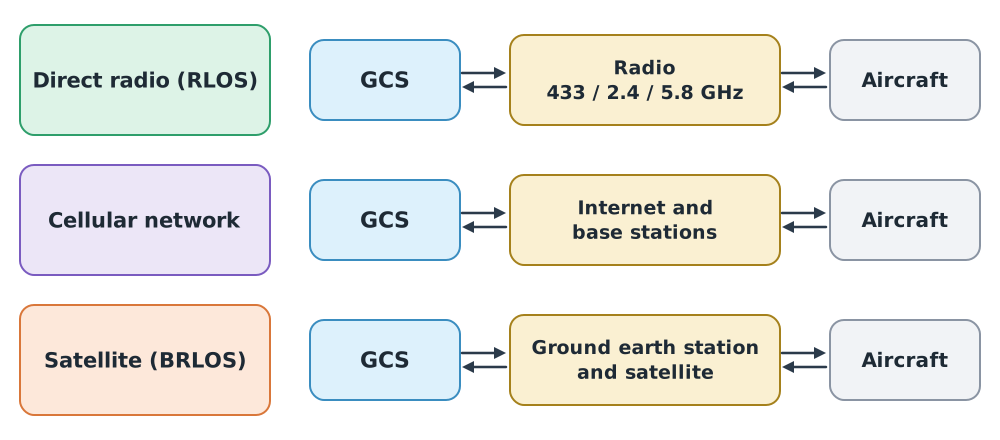
| Type | Strengths | Limitations |
|---|---|---|
| Direct radio (Radio Line of Sight, RLOS) | Low latency; the operator controls the whole system | Range limited by radio horizon, obstacles and transmit power |
| Cellular network | Wide coverage where there is signal | Base stations are designed for ground users, so airborne coverage can be uneven; depends on the network operator |
| Satellite (Beyond Radio Line of Sight, BRLOS) | Covers remote areas | Higher latency; expensive antennas and service |
Many BVLOS operations combine two types, for example direct radio as the primary link near the station and cellular as the backup. Using two dissimilar links reduces the chance that both fail together from a single cause (review parallel reliability in DRT 341 module 1).
The frequency bands allowed in Thailand are set by NBTC notifications, and users must check the current notification before choosing equipment. For larger aircraft, performance standards such as RTCA DO-362 (2016) set minimum performance for terrestrial C2 links.
Fresnel zones and antenna height
Even when the straight line between two antennas is unobstructed, the signal can still weaken if obstacles are close to that line, because radio waves occupy an ellipsoid around it called the first Fresnel zone. ITU-R P.530 gives its radius as:
where and are the distances from the point of interest to the two ends, and , all in kilometres. Designers commonly keep at least about 60% of clear of obstacles.
Example 1 A tree line midway on a 2.4 GHz link
The drone is 2 km from the station, with a tree line at the midpoint ( km).
- m
- Required clearance m
The line between the antennas must pass at least about 4.7 m above the treetops. If it just grazes them, the signal drops even though the two ends “can see each other”. Raising the station antenna helps a great deal.
When the C2 link is lost
Link loss is an event to plan for, not a surprise. RTCA DO-400 (2023) provides guidance on lost C2 link procedures. The key principle is that the aircraft’s behaviour must be predictable: the crew and air traffic services must know in advance what it will do.
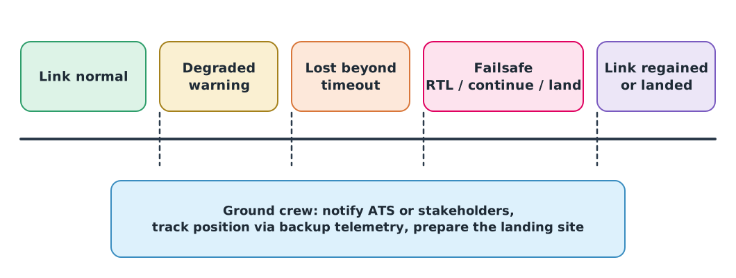
The autopilot does not declare link loss the moment one packet is missed. It waits until a configured timeout expires, and the aircraft keeps flying in the meantime.
Example 2 Distance flown before the failsafe acts
PX4’s default COM_DL_LOSS_T is 10 s, and the drone flies at 12 m/s.
m
In the first 10 seconds after link loss the drone may fly up to 120 m further on its current heading. This distance must fit inside the contingency volume (module 1) and be included in the geofence margin (module 2). A shorter timeout makes the failsafe act sooner, but also more often on brief dropouts, so a balance is needed.
Detect and avoid (DAA)
ICAO Doc 10019 defines DAA as the capability to see, sense or detect conflicting traffic or other hazards and take the appropriate action.
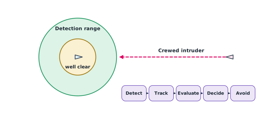
A DAA system works in sequence: detect → track → evaluate whether the encounter will breach the threshold → decide → avoid. The aim is to stay well clear, not merely to avoid collision. For small UAS, ASTM F3442/F3442M-23 uses a well-clear volume of 2000 ft (about 610 m) horizontally and 250 ft (about 76 m) vertically. Larger UAS are covered by RTCA DO-365.
| Sensor type | Examples | Notes |
|---|---|---|
| Cooperative | ADS-B, transponder | Detects only aircraft that carry the equipment and have it switched on |
| Non-cooperative | Radar, EO/IR cameras, acoustic sensors | Detects aircraft that do not transmit, but range and error rates depend on the environment |
| Ground-based | Radar along the route | Adds no weight to the drone but covers only where it is installed |
Example 3 How much time is there to decide?
A helicopter at 100 kt ( m/s) flies head-on towards a drone at 15 m/s. The system detects it at 2000 m.
- Closing speed m/s
- Time to collision point s
- Time until the 610 m horizontal well-clear boundary is breached: s
About 21 seconds must cover confirming the target, deciding, sending the command over the C2 link and the drone changing course. A system that detects at shorter range may not leave enough time. This is why detection range is a core DAA requirement.
Remote ID
Remote ID lets people on the ground, such as officials, identify which drone is flying, where it is and where its pilot is. There are two forms: broadcast, sent directly from the drone over short-range radio, and network, sent over the internet to a service provider. ASTM F3411-22a covers both.
| Required data | FAA Part 89 standard | FAA Part 89 broadcast module | EU 2020/1058 (direct remote ID) |
|---|---|---|---|
| Aircraft identifier | Serial number or session ID | Module serial number | Operator registration number and aircraft serial number |
| Drone position and height | Yes | Yes | Yes |
| Velocity/course | Yes | Yes | Yes |
| Pilot location | Control station position | Take-off location instead | Pilot position (or take-off point if unavailable) |
| Time | Yes | Yes | Yes |
| Emergency status | Yes | No | Not in the Part 6 list |
US Remote ID rules have applied since 16 September 2023. In Thailand, the 2026 CAAT notification does not set Remote ID requirements. Follow new CAAT and NBTC notifications.
Remote ID supports identification and enforcement and is a foundation of UAS traffic management (UTM), but it is not a collision-avoidance system. Most crewed aircraft do not receive Remote ID.
Class activity
Activity: C2 and abnormal events in a simulation
Use exercise B03 “C2 and abnormal events in simulation” from the drone knowledge hub.
- Run the connected, warning and timeout state model with heartbeat ages of 0, 1, 3 and 7 seconds, comparing 5 s and 10 s timeouts.
- Calculate how far the drone flies before the failsafe acts with each timeout at 12 m/s.
- Calculate the Fresnel radius for your group mission link from module 3 and propose an antenna height.
- Tabulate which information comes from C2, the payload link and DAA.
Common mistakes
Watch out
- Calling every event “signal lost” without separating C2, video link and GNSS
- Assuming the link is good because the ends can see each other, ignoring the Fresnel zone
- Setting the link-loss timeout too short, so the failsafe triggers needlessly, or too long, so the aircraft leaves its area
- Relying on ADS-B alone for DAA although some aircraft do not transmit it
- Believing Remote ID helps avoid collisions
Summary
- C2 links come in three main types: direct radio, cellular and satellite. Dissimilar primary and backup links improve reliability
- Keep about 60% of the Fresnel radius clear of obstacles
- Lost-link procedures must make aircraft behaviour predictable; the distance flown before the failsafe acts is
- DAA detects, tracks, evaluates, decides and avoids in order to stay well clear
- Remote ID identifies and locates aircraft; it is not a collision-avoidance system
Check your understanding
- The camera video freezes but telemetry values keep updating. Can you conclude that the C2 link is lost?
- A 5.8 GHz link is 2 km long with an obstacle at the midpoint. What is there?
- A drone flies at 15 m/s with a 5 s link-loss timeout. How far does it fly before the failsafe acts?
- Two aircraft approach head-on with a closing speed of 60 m/s and are detected at 1800 m. How much time is there before collision?
- Under FAA Part 89, what position does a broadcast module send instead of the control station location?
Answers
- No. Frozen video may come from the video link or the display, while updating telemetry shows that C2 downlink data is still arriving. Check each source separately
- m
- m
- s
- The take-off location
Key formulas
| First Fresnel zone radius | |
| Time to collision (head-on) | |
| Distance flown before the failsafe acts |
Key references
- International Civil Aviation Organization. (2015). Manual on remotely piloted aircraft systems (RPAS) (Doc 10019). ICAO. link
- RTCA. (2016). Command and control (C2) data link minimum operational performance standards (MOPS) (terrestrial) (DO-362). link
- RTCA. (2023). Guidance material: Lost C2 link procedures (DO-400). link
- RTCA. (2022). Minimum operational performance standards (MOPS) for detect and avoid (DAA) systems (DO-365C). link
- ASTM International. (2025). Standard specification for detect and avoid system performance requirements (ASTM F3442-25). link
- Federal Aviation Administration. Remote identification of unmanned aircraft, 14 C.F.R. Part 89 (compliance date September 16, 2023). link
- European Commission. (2020). Commission Delegated Regulation (EU) 2020/1058 amending Delegated Regulation (EU) 2019/945 (direct remote identification add-on). link
- ASTM International. (2022). Standard specification for remote ID and tracking (ASTM F3411-22a). link
- International Telecommunication Union. (2015). Propagation data and prediction methods required for the design of terrestrial line-of-sight systems (Recommendation ITU-R P.530-16). link
- International Telecommunication Union. (2024). Calculation of free-space attenuation (Recommendation ITU-R P.525-5). link
- PX4 Autopilot. PX4 user and developer guide. link
Further reading
Study the assigned knowledge units in advance, review media and take the module quiz
C2 link design and lost-link procedures
C2 and abnormal events in simulation
Drone communications and MAVLink
In class / field
Lecture, case discussion and in-class problem solving
Learning evidence: Quiz results and submitted exercises