Mission planning
DRT 342 Mission Planning, Autonomous Operations and Beyond Visual Line of Sight
Lesson
By the end of this module you will be able to
- Explain the mission planning and execution cycle from brief to debrief
- Define the operational area using flight geography, contingency volume and ground risk buffer
- Select aircraft and payload from the mission question
- Lay out a survey pattern from ground sampling distance and image overlap
- Calculate flight time in wind and an energy budget with a reserve
Why this matters
Many drone accidents are not caused by a broken aircraft but by a plan that was not good enough: nobody knew the wind would pick up in the afternoon, nobody budgeted energy for the way back, or nobody noticed a road running under the flight path. Mission planning is therefore a core skill of the professional UAS operator. The more automated the mission, and the further it goes beyond visual line of sight, the harder it is to fix a planning error in the air, because a person is no longer in the control loop every second.
A simple comparison: planning a mission is like planning a long road trip. You need to know why you are going, which route to take, whether you have enough fuel, where you would stop if the car broke down, and who needs to know you are on the road.
This module builds on knowledge units from the drone knowledge hub: writing a brief, assessing a site, integrating weather into the plan, and the mission-concept exercise. Read them before class.
The mission cycle
A good mission does not start with opening a waypoint editor. It starts with the question that needs an answer.
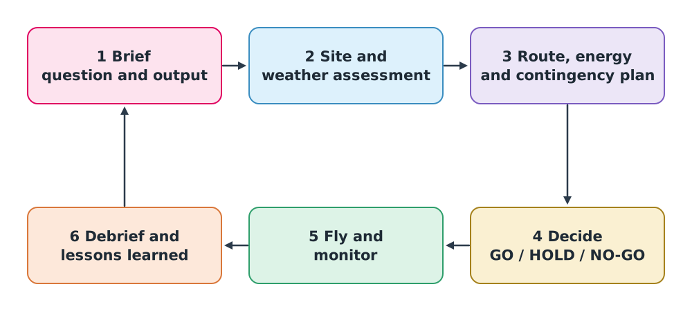
- Brief: state the question, who receives the result, how long the result stays useful, and the team roles. “Imagery no coarser than 3 cm per pixel of a 2 km canal, delivered to the municipality within 48 hours” is far better than “take the clearest possible photos of the canal”.
- Assess the site and weather: obstacles, people, roads, airspace, launch and alternate landing sites, forecasts and observations. Keep “what has been checked” separate from “what is still an assumption”.
- Plan the route, altitude, speed, energy, and the procedures for abnormal events.
- Decide: GO when conditions are met, HOLD when key information is still unconfirmed, NO-GO when risk exceeds the criteria.
- Fly and monitor, comparing actual state with the plan throughout.
- Debrief: record what differed from the plan and feed the lessons into the next mission.
CAAT publishes an Operations Manual (OM) template, CAAT-GM-UAS-001, which has separate sections on responsibilities, planning, site survey and communication. Each operator writes its own procedures in its OM for its aircraft and type of work. The tables in this lesson are exercises only, not a mandatory regulator format.
The operational area
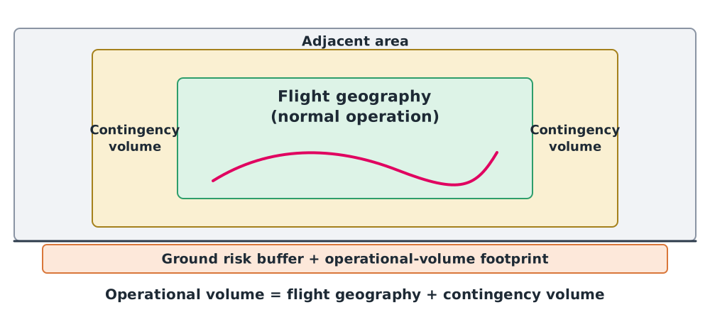
A map with a single flight line is not enough, because a real drone never flies exactly on the line. JARUS SORA 2.5 divides the area into layers, a concept that is useful even for missions that do not use SORA.
| Layer | Meaning | Example of how it is set |
|---|---|---|
| Flight geography | The area and heights where the aircraft flies in normal operation | A 200 m wide canal corridor up to the authorised height |
| Contingency volume | The surrounding volume used in abnormal situations, where contingency procedures return the aircraft to the flight geography | Allows for position error, wind drift and stopping distance |
| Ground risk buffer | Ground area around the operational volume where the aircraft is expected to end its flight if control is lost | SORA 2.5 proposes a 1-to-1 principle, as wide as the flight height, as a starting value |
| Adjacent area | The area further out, assessed for who would be affected if the aircraft escaped | A community or main road next to the work site |
SORA 2.5 states that the operational volume must account for navigation accuracy, flight technical error, path definition (map) error and latencies. It is not drawn by feel.
Selecting the aircraft and payload
Choose from the mission question, not from whatever aircraft is in the store room (review DRT 341 modules 2 and 4).
| Mission question | Resulting requirement | Suitable choice |
|---|---|---|
| Map a 48 ha farm | Wide area, long straight lines | Fixed-wing or VTOL with an RGB or multispectral camera |
| Inspect cracks under a bridge | Hover close to a structure; GNSS may be blocked | Multirotor with a zoom camera and collision protection |
| Search for a missing person at night | See heat, stream live video | Multirotor or VTOL with a thermal camera and video link |
| Inspect a 30 km pipeline | Long range beyond visual line of sight | Fixed-wing or VTOL with long-range C2 (modules 3–4) |
Routes and waypoints
An automated mission is a list of waypoints, each with coordinates, altitude and a command (module 2). Common route patterns are:
- Point to point for delivery or transit to the work area
- Lawnmower survey for mapping
- Orbit around an object for 3D capture
- Linear following of a structure such as a power line or pipeline
Image resolution and survey lines
The ground sampling distance (GSD), the ground size of one pixel, depends on flight height , sensor pixel size and focal length :
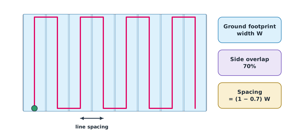
Adjacent images must overlap so that software can stitch them. If the image footprint width on the ground is and the side overlap is , the line spacing is . The photogrammetry is covered in the mapping courses.
Example 1 Laying out survey lines
A camera has a 13.2 mm wide sensor, images 5472 pixels wide and an 8.8 mm lens. It flies at 80 m with 70% side overlap over an area 540 m wide and 800 m long at 10 m/s.
- Pixel size mm
- m cm per pixel
- Footprint width m
- Line spacing m
- Number of lines ; total path m
- Flight time s minutes, excluding take-off and landing
A 3 cm GSD would allow flying up to about 109 m, but the general conditions of Thailand’s 2015 Ministry of Transport notification prohibit flying higher than 90 m above ground; anything higher needs specific authorisation. The calculation is only a technical upper bound.
Energy and wind
Wind changes flight time
Ground velocity is the vector sum of air velocity and wind, . The time for each leg is its distance divided by its ground speed:
Example 2 Does a tailwind cancel a headwind?
A drone flies at 12 m/s airspeed to a point 2 km away and back, with a 4 m/s headwind on the way out.
- Outbound m/s, time s
- Return m/s, time s
- Total 375 s, compared with s in calm air
Wind adds about 12.5% even though there is both a headwind and a tailwind, because more time is spent in the headwind. A multirotor draws nearly constant power over time, so the energy used rises too.
Energy budget
The usable energy is not the energy on the label. Remove the share that should not be used (usable fraction ) and divide by average power :
Operators set a minimum reserve in their OM, for example landing with no less than a stated percentage of energy. This course uses an example policy of “use 80% of battery energy”. Real values must come from the manufacturer and the OM.
Example 3 Can this mission be flown in one sortie?
Use the mission from Example 1. The battery is 22.2 V, 8.0 Ah; average survey power is 350 W; take-off and landing take 2 minutes in total.
- Energy Wh; usable Wh
- Available flight time h minutes
- Required time minutes
Only 0.2 minutes of margin remain, with no allowance for wind, climbing or holding. The mission should be split into two sorties, for example lines 1–8 and 9–16, with the battery change built into the plan.
Class activity
Activity: Build a mission concept pack
Use worksheet B01 from the drone knowledge hub (a hypothetical 2 km canal survey).
- Write a one-page brief with the question, recipient, timing and team roles.
- Sketch the flight geography, contingency volume and ground risk buffer on the practice map, with reasons for each distance.
- Calculate GSD, line spacing and flight time, then check the energy budget with values given by the instructor.
- Build an assumption register listing what still needs checking, the data owner, and the conditions that would trigger HOLD.
The pack is an exercise, not an authorised flight plan.
Common mistakes
Watch out
- Starting by drawing the route before writing the question and deliverable
- Making the flight area exactly as wide as the route, with no contingency volume or ground risk buffer
- Assuming a tailwind on the way back cancels the headwind on the way out
- Using the full label energy without a reserve
- Treating an old map image as the state on the day: no people in the image does not mean no people on the day
Summary
- The mission cycle is brief → site and weather assessment → plan → decide → fly and monitor → debrief
- In the SORA concept the operational area consists of flight geography, contingency volume and ground risk buffer
- Choose aircraft and payload from the mission question
- GSD and line spacing
- Wind always lengthens an out-and-back flight; the energy budget must keep the reserve set in the OM
Check your understanding
- Why is a brief that says “take the clearest possible photos” not enough for planning?
- How does the contingency volume differ from the flight geography?
- Flying at 60 m with a 2.412 µm pixel and an 8.8 mm lens, what is the GSD?
- With a 100 m ground footprint and 75% side overlap, what is the line spacing?
- At 10 m/s airspeed, out and back over 1.5 km with a 5 m/s headwind on the way out, what is the total time compared with calm air?
Answers
- It does not say what the imagery is for, what resolution is needed, who receives it or when, so the team cannot choose height, equipment or acceptance criteria.
- The flight geography is where the aircraft flies in normal operation. The contingency volume surrounds it for abnormal situations, where contingency procedures bring the aircraft back to normal.
- m, about 1.6 cm
- m
- Out s, back s, total 400 s against 300 s in calm air (33% longer)
Key formulas
| Ground velocity | |
| Total time over several legs | |
| Ground sampling distance (GSD) | |
| Survey line spacing | |
| Flight time from energy |
Key references
- Joint Authorities for Rulemaking on Unmanned Systems. (2024). JARUS guidelines on Specific Operations Risk Assessment (SORA), main body, edition 2.5 (JAR-DEL-SRM-SORA-MB-2.5). link
- สำนักงานการบินพลเรือนแห่งประเทศไทย. (2565). รูปแบบคู่มือปฏิบัติการบินของอากาศยานซึ่งไม่มีนักบิน (CAAT-GM-UAS-001, Issue 01 Rev 00). link
- International Organization for Standardization. (2023). Unmanned aircraft systems – Part 3: Operational procedures (ISO 21384-3:2023). link
- Fahlstrom, P. G., Gleason, T. J., & Sadraey, M. H. (2022). Introduction to UAV systems (5th ed.). Wiley.
- Wolf, P. R., Dewitt, B. A., & Wilkinson, B. E. (2014). Elements of photogrammetry with applications in GIS (4th ed.). McGraw-Hill.
- สำนักงานการบินพลเรือนแห่งประเทศไทย. (2569). ประกาศ กพท. เรื่อง หลักเกณฑ์และวิธีการในการอนุญาตให้ผู้บังคับหรือปล่อยอากาศยานซึ่งไม่มีนักบิน ประเภทอากาศยานที่ควบคุมการบินจากภายนอก ที่มีน้ำหนักไม่เกิน 25 กิโลกรัม ปฏิบัติแตกต่างไปจากเงื่อนไขที่กำหนด พ.ศ. 2569 (มีผล 17 พฤษภาคม 2569). link
- กระทรวงคมนาคม. (2558). ประกาศกระทรวงคมนาคม เรื่อง หลักเกณฑ์การขออนุญาตและเงื่อนไขในการบังคับหรือปล่อยอากาศยานซึ่งไม่มีนักบิน ประเภทอากาศยานที่ควบคุมการบินจากภายนอก พ.ศ. 2558. ราชกิจจานุเบกษา, 132(86 ง), 6–12. link
Further reading
Study the assigned knowledge units in advance, review media and take the module quiz
Defining the mission concept
Integrating weather into the mission plan
Brief: questions, deliverables and team roles
Site assessment and go/no-go decisions
In class / field
Lecture, case discussion and in-class problem solving
Learning evidence: Quiz results and submitted exercises